Cheviot Hills
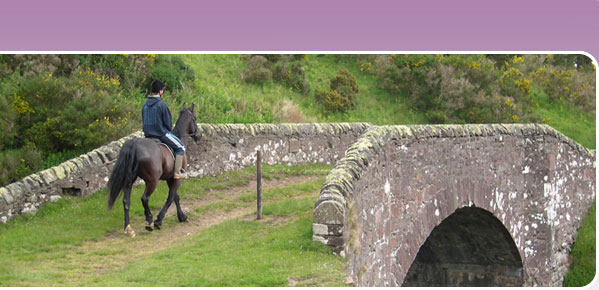
 Few and far between are there places left where you can enjoy the solitude and unspoilt countryside still to be found on the Cheviot Hills. Striding high on the hills or ambling through hidden valleys, one feels a million miles from the stresses and strains of life, yet the Cheviots are within easy reach of Edinburgh, Glasgow, Scotland’s Central Belt and the northeast of England. The Cheviot Routes developed as part of the 350km South of Scotland Countryside Trails (SoSCT) network are equally suitable for walking and horse-riding. These routes offer particularly spectacular horse riding in near solitude on little known routes dating back to the Iron Age.
You can access an online map of the SoSCT Cheviots routes on the BHS EMAGIN website by clicking here. From the Scotland section of "Routes by Region", scroll down the list of routes to Cheviot Hills, which will take you to a street map overview of the routes. By changing the map type in the horizontal menu bar above the map, you can access 1:2,500 OS maps of the routes. Please note that unfortunately the maps currently on BHS EMAGIN listed under Cheviot Hills shown only these routes, but if you go back to the main list and click onto SoSCT, and change map type to 1:2,500 OS, you can track in any direction to see how these routes link up to others in the South of Scotland.
Larger scale maps should be used to follow routes on the ground, such as OS Landranger Map 1:50,000 no. 74 (Kelso and Coldstream), no. 80 (Cheviot Hills and Kielder Water) and OS Explorer Map 1:25,000 OL 16 (The Cheviot Hills).
Services and accommodation
Horses Welcome approved horse and rider accommodation is available at Cliftoncote Farm in the Bowmont Valley, the ideal base from which to start your trail ride, or from which to ride out daily on a variety of different routes.
The nearest shops or pubs serving food are in Yetholm, Morebattle and Jedburgh.
When to enjoy the routes and what to watch out for
May to September is the best time of year to enjoy the Cheviot Routes on horseback. As well as clear way marking you should find most gates horse-friendly, and can be confident that so long as you stick to the route, you will not encounter bogs or major drainage problems. A word of warning though: most of the routes in this area involve exposed hill sections. The paths are easy to follow with a map, but very little shelter is available on the highest sections, and the weather can change quickly at any time of year. Make sure you have suitable clothing to meet all eventualities, food and water. You are also advised to carry a compass (and instructions if you are not confident how to use it!) in case of mist. The nearest shops are at Morebattle, Yetholm, Wooler and Jedburgh.
Linking routes
There is no formally signed or promoted link between the Jedburgh circular riding route and the Hownam end of the SOSCT Cheviot routes, but it is very easy to make your own way, either following Dere Street or quiet country lanes.
The SOSCT Cheviot routes link directly with the Border County Ride on the English side of the border near Barrowburn. The northern extension of the Pennine Bridleway is planned to terminate at Byrness, which will link directly to the SOSCT route network via the Border County Ride.
More about the SOSCT Cheviot routes
Hownam
The quiet hamlet of Hownam in the valley of the Kale Water was, in the seventeenth century, a favourite haunt of the covenanters. Built into the south and east walls of Hownam village church are six old gravestones, a not uncommon economy north of the border.
The Street
The Street was once an important Roman road with 7km of the parish boundary between Hownam and Morebattle running along it. Today it is largely a grassy path, climbing steadily up from Hownam towards the English Border. Take time to stop and admire the panoramic views along the way, as well as the numerous archaeological sites. Not for nothing did our ancestors build their forts and settlements high on the Cheviot Hills, where they had clear views of potential enemies approaching. South of the border, The Street continues as a grassy path, skirting around the edge of Otterburn Rangers to the small village of Alwinton.
Clennell Street
For many years Clennell Street served as a drove road along which cattle were moved from the fertile Tweed Valley to the hungry markets of industrial Tyneside. The farm steading Cocklawfoot at the end of the quiet public road, which winds its way up the sleepy valley of the River Bowmont was an inn for many years, thriving on the trade of passing drovers. From here, take your horse along a grassy track that climbs steadily upwards through enclosed fields (in-bye) to open hill. Look out for the old forts above and below the track beyond the shelterbelt.
Straddling the border between Clennell Street and the Street lies Windy Gyle. With 360-degree panoramic views across to the Northumbrian coast, English Lakes, Tweeddale and the Southern Uplands, it is no wonder that this was chosen as a fitting place for the burial of Iron Age chieftains.