Gypsy Glen route
Described here as a circular half/full day ride (depending how fast you go!), but with various shorter options, this route takes its name from the small wooded glen through which the Haystoun Burn flows at the western end of the route, from where it follows the old drove road south over Birkscairn Hill and Stake Law before circling back past the fairytale castle at The Glen, up a glorious grass track to Cardrona Forest.
You can download a map for the Gypsy Glen route from the BHS EMAGIN website. From the Scotland section of "Routes by Region", scroll down the list of routes to South of Scotland Countryside Trails, which will take you to a street mapping scale overview of the route network. Gypsy Glen runs south from Peebles. By changing the map type in the horizontal menu bar above the map, you can access a 1:2,500 scale map which shows the route in more detail, and allows you to track in any direction to identify other linking routes promoted through SoSCT.
Location Tweed Valley in the Scottish Borders between Peebles and Innerleithen
Access and parking Forestry Commission public car park at Cardrona Forest OSGRNT293383 has public toilets and usually has plenty of space but please park with consideration for other visitors and clear up any droppings.
Alternative parking in main public car park at Peebles on south side of River Tweed (immediately east of the B7062 bridge) but gets very busy at weekends and in summer.
Season Best on a fine day in spring, summer or autumn. Avoid wet weather when the higher ground can be boggy, particularly in winter.
Going Relatively steep climb up former drove road on grass/firm track, levels out higher up with some good canters along firm heathery track; some damp patches on top but no serious bogs if you keep to the track; farm track on eastern arm; tracks through Cardrona Forest mixture of grass paths and stoned forest road. Public road between Cardrona Forest and start of Gypsy Glen route.
Attractions
* Spectacular scenery
* Iconic historic route between twin dykes of the old drove road which was once the main route south for cattle from the Highlands heading for Smithfield market in London
* Variety of route options
* Option to shortcut if necessary
Challenges The route is easy to follow at either end but is not clearly waymarked around Stake Law – make sure you have an OS Explorer 1:2,500 map with you (and know how to read it!).
Exposure on the highest section(s) - in mist or bad weather it is probably better to choose an alternative route.
Relatively steep climb between river and Craig Head.
Services Petrol station, numerous cafes, food shops and supermarket in Peebles but parking with a lorry/trailer is not always easy.
Route description
- From Cardrona Forest car park, turn left (west) along the B7062 towards Peebles, which runs parallel to the south side of the River Tweed. Although usually fairly quiet, watch out for cyclists on the Tweed Cycle Route, and take particular care on bends. Carry on along the road past Kailzie Gardens and Scotsmill, past the small industrial estate on your right. Ignore the track to your left up to Whitehaugh Farm and a new housing development, which (contrary to the OS map) no longer links through to Gypsy Glen.
- Turn left up Glensax Road through a housing estate. Follow the road straight ahead, ignoring turns to the right and left, until you reach a T-junction.
- Turn left along Glen Road, and continue straight along this road heading south-east.
- At the end of the tarmac road, follow the track which continues directly ahead on the same line as the road between an avenue of trees, which is signed by a fingerpost to Gypsy Glen immediately after the track leading up to Hayston House and estate to your right.
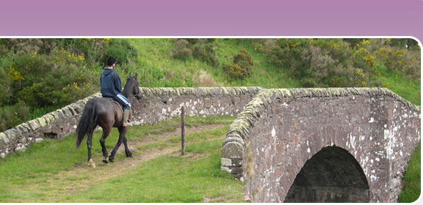
- Follow the old beaten earth drove road between the trees. An information board on a stone cairn will tell you more about the history of this route. As the track bends right, continue over the horse stile (put in to prevent illegal motorcycle use) or through the adjacent gate across the track. The path narrows as it leads down to Haystoun Burn, with a fence and paddock on your left and trees on your right. Known locally as Gypsy Glen, there is a long history of travellers camping here.
- Cross the burn by the shallow ford immediately before the footbridge, climbing up the bank opposite. The foundations of one of the parallel dykes which once enclosed the old drove road now offer firm footings for the track as it climbs up the hill.
- Keeping the wood on your left, continue climbing south-east up the track. Beyond the wood, the old drove road becomes grassier across more open ground, still with a dyke running parallel on your right. Go straight through the new self-closing bridlegate in the line of the path, and carry straight on along the track, still climbing ever upwards, through another gate, around the eastern flank of Craig Head, and then through a further gate before climbing again between parallel stone dykes, up through the heather to Kailzie HiIl. Stopping every so often to look back over the Tweed Valley, with Peebles Hydro clearly visible on the far side of the river, is a good opportunity to catch your breath.
- The twin dykes come to an end at Kailzie Hill, but the track is still very clearly visible, continuing due south with the forest on your left (east), climbing up and over Kirkhope Law. There may be the odd soft patch but you should be able to pick your way around without any problem. At the end of the forestry, a gate to your left leads east down to The Glen, which offers a shortcut if the weather is bad or you want a shorter route.
- For the longer route, continue south along the old drove road, keeping the fence on your left (east) climbing up Yellow Mire Hill to Birkscairn Hill. Take time to admire the spectacular views all around. As you drop down from the summit parallel to the fence, look out for a fingerpost which signs the route south through a bridlegate. Follow the path through the heather, cutting diagonally across the corner, over the remains of a former dyke, beyond which the old drove road continues south across open ground around the eastern flanks of the main summit of Stake Law. Although less well defined than previously, the ruts of the old drove road are usually fairly easy to pick out. In places the old track now runs as a ditch with the track up above it on the banks, at times crossing from one side to the other of the former sunken road, and with new culvert pipes in places to shed the water off the track.
- Cross three burns, ignoring any sheep tracks off to the east, and keeping west of the lower summit of Stake Law shown on the map. The track becomes much clearer again as it climbs up after the third (Banks) burn, and then levels out, still heading roughly south. Look down to your left (east) for the distinctive Scots Pine and circular wall around the shooting bothy at Glensheil Banks, where you are headed. Approximately 0.5km after the burn, there should be a waymark post indicating a grass track, but if you miss the post or cattle have knocked it over, pick your own way down the face of the hill towards Glenshiel Banks, which is a lovely spot for a picnic.
- The promoted route leads north through the gate in the dyke, passing the bothy on your left, through another gate and then along the firm track which runs parallel to and below Chester Rig north-east to Glen House. Alternatively, instead of going through the gate into Glenshiel Banks, cross the burn on the main track heading south-east. Immediately over the burn, turn left (east). There is no clear path, but it is easy to pick your way staying parallel to Glenshiel Burn, until you pick up the track which leads through to Loch Eddy. The grass banks next to the boathouse are another idyllic picnic spot. From the loch, the track which follows the Quair Water north-east up The Glen is an easy and enjoyable ride, unfenced for part of the way so you can pick up speed on the grass alongside. Look out for the memorial to the two Tennant brothers on your right at the southern end of the lime tree avenue. Keep on the main stoned track as it bends sharp left to rejoin the alternative route near Glen House.
- From the fingerpost south-west of Glen House, opposite the old walled garden, follow the road past the farm steading and estate houses for approximately 0.8 km until you see a fingerpost signing a stone track just before the gamekeeper’s cottage. Turn left (north-west) up this track for approx. 0.4km, and then turn right, following the waymarks on the track through the wood, to the gate which leads out onto the open hill.
- Go through the gate, directly ahead across the culvert bridge over the burn, climbing roughly north up the grass track which skirts around the east of Orchard Rig – a fantastic canter if you have any energy left!
- You may find the waymark post at the Y-junction in the track has been knocked over by cattle. Whichever arm you follow, you will end up in the same place, but it is easier to take the left fork which follows a more clearly defined track north-west, up the south side of the dry valley, to the bridlegate in the forest boundary fence at Beards Hill. Watch out for mountain bikes and occasionally scrambling bikes.
- Go through the gate and continue straight on, heading north-north-west, along the main track with standing trees on your left and a felled area on your right. Another forest road will join from your left. Approximatley 0.8km from where you entered the forest, there is a former timber stacking area where the forest road takes a hairpin bend to the right. A more enjoyable route on horseback is to follow the waymark post to the left on this bend, which takes you north-west along an attractive path through the trees. At the junction with the next forest road, turn right (east) along the main forest track heading gently uphill (ignore the narrow path opposite which is unsuitable for horses).
- At the t-junction with the main forest road, not long after you have crossed a culvert bridge over Glenpeggy Burn, turn left, heading north, which will lead you gradually downhill along the western edge of Cardrona Forest, back to the forest car park.
Alternative routes
- For a shorter route, turn off through the gate at the edge of Yellow Mire forest (OSGR273344 – take care as the gate is sometimes off its hinges) and follow the new path which links through to the estate track which skirts the tip of the forest at Little Craigie Side. Cattle often congregate around the winter feeding areas directly across the track shown on the map, so rather than following the main track leading down to Birks, an alternative recommended route is waymarked which branches off the main stone track and follows the contour below the dyke along the hillside north of Glass Burn, crossing back over the burn just before the sheepfold to join the track leading through a gate down to the gate into the wood at OSGR299339. From there you can circle back around Orchard Rig and Cardrona Forest.
- A rough grass path links between the gate in the forest boundary at Beards Hill and the tip of the wood at Little Craigie Side, running along the hill side of the forest fence.
- Cardrona Forest offers a whole network of tracks and forest roads to explore, which you can use to extend the route described above, or to create independent circular routes. Turning right (north-east) along the side of the forest as soon as you have passed through the bridlegate at Beards Hill will take you over Grieston Hill and to the north-east edge of Cardrona Forrest. A new link path leads from the easternmost tip of the forest down to Howford.
- Note that the former path recommended in some old route guides and on some old edition maps between Kailzie Hill and Cardrona Forest no longer exists. Theclaimed Please note that the claimed right of way between Cardrona Forest and Laverlaw is currently obstructed to horses.