Ae Forest
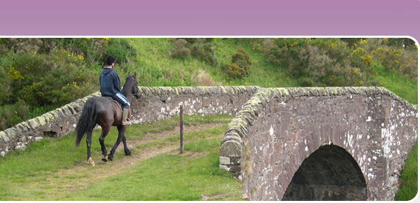
 This linear route through Ae Forest for horse-riders, cyclists and walkers was originally developed as the western arm of the 350km South of Scotland Countryside Trails (SoSCT) network, linking Dumfries & Galloway with the Borders. It is now part of the Romans and Reivers route, one of Scotland's Great Trails, and also promoted as the off-road cycle route between Dumfries and Moffat.
The trail starts at Ae, which is easily accessed off the A701 north-east of Dumfries, and links through to Beattock and Moffat. The track is stone surfaced, of varying gradient and able to withstand use at any time of year.
There are many other tracks linking up with the linear Romans and Reivers/SoSCT route, so if you fancy a circular route you can plan your own according to how far you want to go.
Ae Forest is at the heart of the Seven Stanes mountain bike trails, so this is the ideal place to come with friends, family or a partner keen to go off and explore on their bike while you head off on your horse.
Finding your way
You can download a map of the Ae riding route (and Ae Forest section of the Romans and Reivers Route) from https://www.bhsaccess.org.uk/ridemaps/Ridingmap.php?file=Aeforest. Maps of the other sections of the Romans and Reivers route can be downloaded form the same website.
The Ae Riding route is clearly way marked throughout on the ground, and is easy to follow – just look out for the SoSCT arrows and Romans and Reivers logo disks. Although the mapped route is linear, there are many other forest tracks and rides which you can combine with the formally promoted SoSCT route to create your own circular routes of different lengths. Other linking paths and tracks may be waymarked as part of the Seven Stanes mountain bike routes, or as walking routes, but only the linear Ae Forest to Beattock route is waymarked as part of the SoSCT network.
Larger scale maps should be used to follow routes on the ground, such as OS Landranger Maps 1:50,000 no. 78 (Nithsdale and Annandale) and Pathfinders 1:25,000 no. 495 (Moffat), no. 505 (Thornhill), no. 506 (St Ann’s and Boreland) and no. 517 (Dunscore and Ae).
Parking
There is ample pay and display parking at At Forest. Trailers and horseboxes are recommended to use the original (main) car park which has much more space for parking, turning and loading. Follow the signs along the road north-east from Ae village, down over the river, ignoring the small car park near the cafe, turning left on the bend along the stone track and you will find the main car park clearly signed on your left on entry to the forest. The waymarked multi-use route runs parallel to the east side of the stoned track, along the field headland, avoiding the cattle grids and traffic along the forest road.
There is also parking at the eastern end of the route where it exits the forest above Beattock just east of Kinnelhead, but please note that the Crooked Road which leads up to the latter is single track in places and some horse boxes may struggle with the gradient.
Watch out for...
Be aware that Ae Forest is very popular with mountain bikers and with walkers (some with dogs). Also remember that this is a working forest. Where felling or other forestry operations are underway, any necessary diversions will be clearly signed. Please respect warning signs and keep clear of machinery or stacked timber.
Linking routes
From Beattock you can continue east along the SOSCT network to Eskdalemuir, where you might like to visit the Samye Ling Tibetan Monastery. For further details of this route, click here.
From Eskdalemuir, the SOSCT network links to the old Roman Road through Craik Forest and then on to Hawick, where it links with the Hawick Circular Riding Route and Buccleuch Country Rides.
More about the route
Ae Forest offers a network of forest tracks and minor roads for horse-riders, cyclists and walkers of all ages and abilities to enjoy throughout the year. The forests are managed for timber production, recreation and conservation. Birds of prey such as short-eared owl, buzzard and goshawk regularly nest and hunt in the forest.
The views along the Ae Forest Route are forever changing. As you start to climb uphill with your horse away from Ae look south to the Solway Firth and Criffel. On a clear day you see as far as the Lake District hills. As you follow the riding trail further north Queensberry and Wee Queensberry come into view and dominate the skyline. Further north still to Earshaig the Southern Upland and Moffat Hills form a backdrop to the narrow Crooked Road winding its way down to Beattock.