Eskdalemuir to Hawick
The Romans built a road linking Eskdalemuir and Craik, west of Hawick, but although clearly marked on the map, most of this historic track had for many years been impassable on foot and inaccessible on horseback. As such, there was no off-road link between Dumfries and Galloway and the Scottish Borders. Under South of Scotland Countryside Trails, a new linear route designed specifically for walkers, cyclists and horse-riders was established linking Eskdalemuir to the Hawick Riding route, based on the old Roman road between Eskdalemuir and Craik, and then following former drove roads east to Hawick. In celebration of the rich history of the countryside through which it passes, the linear route between Ae Forest and Hawick is now waymarked and promoted as the Romans and Reivers route.
Parking
The large Forestry Commission car park at Craik, west of Hawick, has ample space for trailers and horse boxes, and there are various other forest roads and trails to explore in either direction from there within Craik Forest, as well as the waymarked SOSCT route.
Finding Your Way and When to Enjoy this route
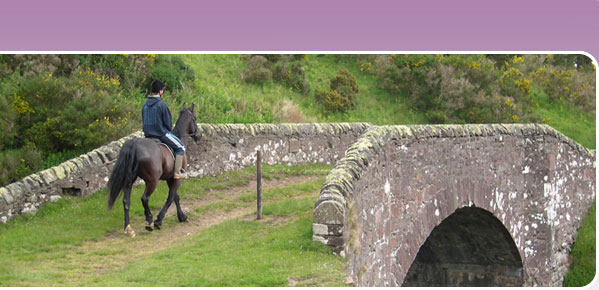
The main linear SOSCT route is cleary waymarked and the surface is suitable for use most of the year, although as this is a fairly remote area, it is best enjoyed from spring to autumn. Barefoot horses may appreciate boots at least some of the way as there is a fair proportion on stony forest roads.
Between Chisholme and Roberton the waymarked route follows farm tracks and an informal path. The narrow metal footbridge over the Borthwick Water has steep steps either end and is therefore inaccessible with a horse. There is a ford approximately 20 metres downstream in line with the gates. When the Borthwick Water is in spate during or after very wet weather, or if your horse doesn't like water, you may prefer to follow the road through Burnfoot and Roberton, or follow the road east from Chisholme past Branxholmtown to link onto the Hawick circular riding route just before Branholme Bridge, from where you can link back to the Romans and Reivers route on the west side of Borthaugh Hill.
You can download a map for this or any of the other SoSCT routes via https://www.bhsaccess.org.uk/ridemaps/Ridingmap.php?file=scotland/Public/Romansandreivers.
Services
Accommodation is available at Eskdalemuir, Craik or Wiltonburn Farm west of Hawick, but please note that you will pass little other habitation between Eskdalemuir and Roberton. There are no services in Eskdalemuir other than a cafe and small shop at Samye Ling Tibetan Monastery. On the Borders side of the route, the nearest shops are at Hawick.
More about the route
Enjoy the beautiful view at Craik summit. A circular mound marks the remains of what is thought to have been a Roman signal station. Craik Cross Hill seems the natural choice of location for a signal station given the clear views to other known Roman sites at Burnswark, Ruberslaw and Eildon Hill North.
The Roman road through Craik is now visible only as a line through the trees, but at one time echoed to the sound of Roman armies on the march as they defended the northernmost part of their empire. The road ran in a straight line to provide the most direct link possible between the Roman forts of Raeburnfoot at Eskdalemuir with Trimontium near Melrose.
Messengers and relay riders are known to have been the most common forms of communication used by the Romans, but a faster means of communicating was essential to the co-ordination of the Roman military in times of crisis. While standards and bugle blowing would be effective over short distances, lighted beacons would have been the obvious choice for longer distance signalling. Smoke would be visible by day, and light from the beacon fires visible by night. The beacons could be combined to form chains and relay networks, and the only equipment or expertise required was the ability to light a fire.
Linking routes
The SOSCT route from Eskdalemuir to Hawick links directly onto the Hawick Circular Riding Route west of Hawick. Heading north around the Hawick Riding Route, you can link north onto the Buccleuch Rides around Ettrickbridge and Bowhill, and from there pick up the SOSCT Minch Moor route at Yarrowford which will take you over to the Tweed Valley at Traquair.
Alternatively heading south (anticlockwise) around the Hawick circular riding route, you can link onto the Waverley Way, a disused railway line which leads down towards Newcastleton, or from which you can branch east via Bloody Bush over to Kielder Forest.
You can continue west from Eskdalemuir on the linear SOSCT route which leads through to Moffat, Beattock and Ae Forest.