Biggar to Broughton
Two-thirds of this enjoyable circular route is off-road, half on disused railway and the other along an old drove road. Spanning the border between South Lanarkshire and the Scottish Borders, it is an ideal half-day or summer evening ride. For those who want to go fast, there is plenty of scope for some good long canters or gallops, and for those who prefer to take their time, the views from the old drove road between Skirling and Broughton are fantastic.
Distance Approx. 17km
Location: Between Biggar in South Lanarkshire and Broughton in the Scottish Borders, south of the Pentland Hills
Maps
OS Landranger no. 72 (Upper Clyde Valley)
OS Explorer no. OL 336 (Broughton and Biggar).
You can download an online map of the Biggar to Broughton route from the BHS Emagin website. From the Scotland section of "Routes by Region", scroll down the list to Biggar and Broughton. To change the scale to 1:2,500 OS map, click on the map type on the horizontal menu along the top. Note that both of these maps are specific to this individual route, but if you look at the 1:2,500 scale map under the main SoSCT section of the Scotland Routes by Region page, you can track in any direction to identify other linking routes which form part of the SoSCT network.
Access and parking:
No formally agreed parking arrangements but there is normally ample space at Biggar Golf Course (follow the signs for Biggar Little Theatre and carry on down to the end of the road, next to the park and boating pond). Alternatively there may be space at the cattle market at the eastern end of Biggar. Either way, you are advised to turn your trailer/box when you arrive in case the car park fills up while you are out riding, and if you are meeting with friends and are looking for parking for several boxes/trailers, ring in advance. Please respect other users of these car parking areas and clear up any droppings or other mess.
Season Accessible all year, particularly disused railway – if it is really wet and you want a blast, ride to Broughton and retrace your steps. The highest point of the drove road is more exposed in wet weather and may be wet underfoot but no serious bogs.
Going Firm grass turf and level gradient of disused railway allows you to go as fast as you want (remember to stop at the gates!) Old drove road through undulating wood and fields, with scope for a good gallop up the steepest climb
Watch out for
Watch out for rabbit holes on the section around Corstane Hill. There are sometimes ponies loose in this field, and the field to the west of here.
The old drove road from Broughton to Skirling was not included in Tweed Trails so is not waymarked and you may have to dismount to negotiate the gates, but is easy to follow.
Services Petrol station, numerous cafes, food shops and supermarket in Biggar. Cafe and local shop at Broughton.
Linking routes
From Broughton you can follow the John Buchan Way east to Peebles, where you can link direct onto other SOSCT routes heading via Lyne and Cloich Forest via the Cross Borders Drove Road over to West Linton, where there are further SOSCT routes. Alternatively from Peebles you could continue east towards Traquair, linking via the Minch Moor and Yarrowford to the Buccleuch Rides at Bowhill and Ettrickbridge.
Route description
(You can ride the route in either direction by following these directions in reverse)
From the car park next to the golf club house, take the red stoned track between the golf course and the boating lake. Where the track meets the burn, turn left, which will take you onto the disused railway through a self-closing gate before the sewage works.
The disused railway continues for 7km right the way through to Broughton. All of the gates along the route have been replaced so that you should be able to open them without dismounting. Wooden railings have been erected across the culverts and burn crossings but please take extra care when negotiating gates next to the railings. Parts of the disused railway are sometimes grazed by cattle and sheep. Please leave all gates as you find them, making sure to securely close any which were shut when you came to them, but also leave open any which had been left deliberately so.
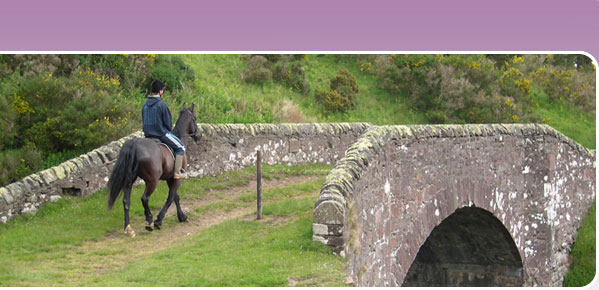
At the Broughton end of the disused railway, immediately past the service centre on your right, you will reach a gate which restricts access to the coal yard. Follow the rather unpromising but clearly waymarked path around to the left (i.e. north) of the coal yard fence, across the wooden bridge over the Biggar Water to Broughton Brewery. This bridge has recently been rebuilt specifically to accommodate walkers, cyclists and horse-riders and most horses will cross it without any difficulty but if in doubt, please dismount and lead your horse over the bridge. (The brewery is on the site of the former slaughterhouse, sheep were downloaded from trains across the former bridge.) On the brewery side of the bridge, turn right along the tarmac brewery access road to the A701. Turn left (north) onto the A701 through Broughton.
Turn left at the café on the road towards Biggar and almost immediately right, just before a new house with a turret, following the track uphill past an old house on the right to the grass drove road which is enclosed by parallel dykes/hedges on either side as it climbs up the hill in front of you. Take care to close the gate or fence which is usually fastened across the lower end of the track, and beware of rabbit holes and occasionally loose horses through the next gorsey section. Once through the gorse, carry on around the contour of the hill to a gate across the track which you pass straight through – watch out for live electric wire adjacent to this gate.
Carry on along the track heading with the dyke on your left, through another gate onto rough grazing. Keep heading in the same direction – north-west towards Skirling - with Burnetland Hill on your right, to the left (south) corner of a small shelterbelt. Depending on the weather and time of year, there may be some damp patches on this section or shallow ditches to ford (or jump) but it is usually quite easy to pick your way through without any problems. Go straight ahead through the gate in the fence to the south of the shelterbelt to carry on in the same direction you were going. Keep parallel to the fence on your right as you head downhill, through another gate, to Kirklawhill Burn. Ford or jump the burn, and go straight through the gate at the top of the opposite bank, to climb up the hill through the shelterbelt following the old drove road through to Skirling. (If the drove road through the trees is blocked by vegetation, branches or cattle, you can divert into the fields adjacent and continue parallel to the old drove road until the next gate allows access back onto it.) You will come out in the north-east corner of the village green in Skirling. Turn left, around the village green, and then left again along the A72 for a short distance before branching off to the left on a minor road past Spittal Farm and Skirling Mains. At the t-junction with B7016, turn right (west) and follow this road back into Biggar. The first left at the puppet theatre takes you back down to the golf course.
Accessing the disused railway from Broughton:
Limited parking in Broughton village other than behind the village hall, which is across a narrow bridge which is unsuitable for lorries. Please make sure that you do not block access to the school opposite the brewery during term-time. If you do park in the lay-by outside the school, it is suggested that you turn your trailer on arrival to avoid getting jammed in!
To get onto the disused railway from Broughton, go down the tarmac access road to Broughton Brewery which is parallel to and immediately north of the Biggar Water, just south of the school. Follow the path around the left side of the brewery buildings across the wooden bridge over Biggar Water, continuing right over the bridge around the coal yard fence onto the disused railway which leads you to Biggar.